Showing posts with label Parliamentary Gazetteer Extracts. Show all posts

Monday, 9 March 2026

Tollymore Park: 1846

Click to Enlarge
THE PARLIAMENTARY GAZETTEER OF IRELAND, DATED 1846, PROVIDES A FITTING DESCRIPTION OF THE GRANDEUR OF TOLLYMORE PARK, ANCESTRAL SEAT OF THE EARLS OF RODEN


TOLLYMORE PARK, or TULLAMORE PARK, the superb demesne of the Earl of Roden, in the parish of Kilcoo, barony of Upper Iveagh, County Down, is situated on the rivulet Shimna, at the north-west base of Slieve Donard, adjacent to the south side of the village of Bryansford.


The mansion is a plain though commodious building; yet the demesne, in consequence partly of its artificial decorations, but chiefly of its natural character, is one of the most magnificently picturesque in the British dominions.

Its woods extend about two miles along the base of Slieve Donard, and contain some of the finest larch in the Kingdom.
"Tullamore Park," observe Mr and Mrs Hall, "is a place which Nature had prepared to receive the improvements of art." 
"It is situated in the midst of most sublime scenery, with the wide expanse of ocean open before it; yet nowhere do the trees grow with greater luxuriance."
"Through this delicious spot rush the assembled mountain rivulets, creating in their passage cascades of every variety of force and form." 
"It is scarcely possible to imagine a scene where natural beauties and advantages have been turned to more valuable account by judgment, skill, and taste, than this which lies at the foot of Slieve Donard, and almost on the brink of the ocean."

"Entering the grand gate," says Mr Atkinson, "we proceeded by a row of excellent offices, with a tower, clock, and spire, to inspect the demesne."

"The lofty mountains of Mourne, with Slieve Donard in the rear of this grand group, and an extensive green mountain, richly planted, that skirts the lawn, bear full upon your view as you enter the grand gate."

"In your descent from this gate to the lawn, you not only pass by the spire and offices attached to the house, but also a small pleasure garden; and after moving twenty or thirty paces towards the lawn, a landscape inconceivably grand presents itself."

"In your approach through the gate, you are entertained with a grand mountain view through a defile; but here, to the majesty of the Mourne Mountains, which overhang the landscape in front, and the planted mountain of more modest altitude that bounds the lawn, with a most interesting cottage on its declivity, are added the variegated beauties of an open country, and the entire rich and picturesque group of features that characterize the home view."

"Among the former may be included, as of prime importance to the general scene, the Irish Channel on the left-hand, with Felix Magennis's famous castle on the seashore."

"Among the latter, the woody hills and glens of the demesne, extending to the right in front of the lawn; the interesting cottage on the declivity of the planted mountain; and on the lawn itself, a beautiful MONUMENT erected to the memory of the Hon James Jocelyn RN, second son of the late Earl of Roden."

"Tullamore Park is reputed to contain 1,200 Irish acres; and we may truly say that such a combination of wood and water, of lofty mountains with lowly valleys, and of all which is necessary to fill the vastness of the imagination with an impression of the grandeur and beauty of a perfect scene, we have seldom witnessed in our travels through this country."

First published in March, 2020.

Tuesday, 6 January 2026

Kilrea Manor House

THE WORSHIPFUL COMPANY OF MERCERS OWNED
21,241 ACRES OF LAND IN COUNTY LONDONDERRY


"KILREA," the parliamentary gazetteer tells us, "a post and market town, stands at the intersection of the road from Portglenone to Coleraine, with that from Maghera to Ballymena."

"It presents an improving appearance, and possesses a prosperous character."

"The Mercers' Company, to whom it belongs, have built in it an agent's house, a public school, a police barrack, a hotel, and a market-house; and they seem to be wisely as well as strongly studious to promote its well-being."

"Some new lines of road, recently formed to connect the two sides of the basin of the Lower Bann, have greatly facillitated intercourse, and materially increased local business."

"The principal trade of the town consists of the weaving of linen, the sale of agricultural produce, and the conveyance of goods along the river Bann."

It is situated on the western shore of the river Bann, over which is a substantial stone bridge of seven arches, forming a link between Kilrea and County Antrim.

Kilrea Manor house (Image: The Manor House & Golf Club)

THE MANOR HOUSE, Kilrea, County Londonderry, is a two-storey Georgian house with a basement, built in 1835 as an official residence for the agents of the Mercers' Company.

The building cost £4,000 (equivalent to about £520,000 today), and the architect was William Barnes.

The first agent to reside in the manor house was William Henry Holmes (c1765-c1846); succeeded by George Bicknell; ROBERT DOLLING; and, in 1878, Sir William Richard Holmes (1822-82).

Kilrea Manor (Image: The Manor House & Golf Club)

Accommodation within the estate included offices, stables, laundry, coach-house, garden-house, gate lodge, and a home farm.

James Fisher resided in the manor house in 1887; and in the early 20th century, a Dr James Lennox (c1862-1924) lived in eighteen of the rooms.

The Mercers’ Company still owned the manor house till the early 20th century; by 1935, however, the estate was occupied by St Anne’s Convent of Mercy.

Kilrea Manor (Image: The Manor House & Golf Club)

A school operated by the convent was located within the grounds, in the former stable and coach-house. 

The buildings were occupied by the convent until the mid to late 20th century, and have since been re-modelled and expanded to function as a restaurant and golf club.

The nine-hole golf course opened in 1991.

First published in January, 2021.

Monday, 29 December 2025

Castlewellan

EDITED EXTRACTS FROM THE PARLIAMENTARY GAZETTEER OF IRELAND, PUBLISHED IN 1846


CASTLEWELLAN, a small market and post town in the parish of Kilmegan, barony of Upper Iveagh, County Down.

It stands on the road from Newry to Downpatrick.

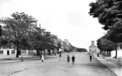
The beauty, symmetry, and pretending bulk of this village, with its market-house and spire [the spire was removed ca 1846]; the stirring and prosperous aspect of two bleaching establishments in an adjacent valley on the north-west; the richly planted hills which close up the environs in the direction of Clough.

Prospect from The Square, Castlewellan (Image: William Alfred Green)

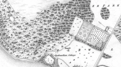
The superb grounds of CASTLEWELLAN DEMESNE, in the opposite direction, with its profuse plantations, and the spheric cone of its beautiful Gothic temple*; and the melting of this demesne into the instant and grand perspective of the Mourne mountains; render the village and its environs one of the most magnificent and imposing scenes in the county.

The mills of the two bleach-yards are turned by a stream which issues from a lake in Castlewellan demesne; and about twenty years ago, they annually finished 7,000 or 8,000 pieces of linen.

A weekly market is held for the sale of linen yarn and agricultural produce; and fairs are held on February 1st, May 1st, June 1st, September 1st, November 13th, and the Tuesday before Christmas.

Click on image to enlarge

Castlewellan mansion is the seat of the EARL ANNESLEY; its appendages are a lodge, a Gothic temple, and a farmyard; its demesne comprehend 400 or 500 acres of hill and dale, and so richly combine artificial ornament, practical utility, and natural landscape, as to present to tourists uniqueness in blending with power and beauty.

Its views, especially from the vantage ground on which the temple stands, are such, says Mr Atkinson, as "can only be tasted with rapture by that eye through which the majesty of Nature communicates itself a silent eloquence to the imagination."

The ancestor of the Earl Annesley was created Baron Annesley, of Castlewellan, in 1758.

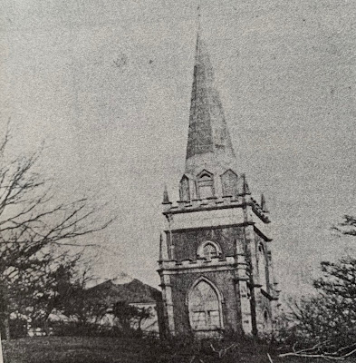
The Temple, Castlewellan demesne, ca 1855 (Image: Ulster Architectural Heritage Society)

*THE TEMPLE, formerly on the site of the present mansion house, was demolished in 1855. Its demeanour was perhaps akin to similar buildings in Tollymore Park and Hillsborough. The late Peter Rankin, who wrote Historic Buildings in the Mourne Area of South Down for the Ulster Architectural Heritage Society in 1975, dates it to ca 1820.

First published in December, 2021.

Thursday, 18 December 2025

Markethill

EDITED EXTRACTS FROM THE PARLIAMENTARY GAZETTEER OF IRELAND, PUBLISHED IN 1846


MARKETHILL, a small market and post town in the parishes of Mullaghbrack and Kilclooney, barony of Lower Fews, County Armagh.

It stands on the road from Armagh to Newry.

Main Street, Markethill (Image: Ebay)

The surrounding country, though minutely subdivided into small holdings, is remarkable for the comfortable appearance of its cottages, the snug condition of its little farms, and the very improved, and, in some respects, peculiar state of its agriculture; the last, in a great measure, the result of the spirited and enlightened exertions of MR BLACKER, the land agent of LORD GOSFORD and COLONEL CLOSE.

Nearly three miles west of the town, and forming a conspicuous feature in an extensive landscape, is the remarkable hill called Vicar's Cairn, whose summit has an altitude of 814 feet above sea-level.

In the vicinity of the town is Draper's Hill [in Gosford Forest Park], celebrated in the writings of DEAN SWIFT.


Immediately adjacent to the town on the north and east, and to a certain extent closely and warmly sheltering it, is the handsome demesne of GOSFORD CASTLE, the seat of Lord Gosford, the proprietor of the town.

The present mansion was built only three or four years ago, and is a large edifice,  in the early style of castellated baronial architecture.

Bryandrum Cottage adjoins the east side of the demesne; and other small seats are in the neighbourhood.

The town has a bridewell [prison], a neat court-house, a good inn, and several well-built houses.

The bridewell is quite new, has sufficient accommodation for the wants of the district, and is kept in a very clean and good condition.

Markethill is the station of the staff of the county militia, and the seat of a court of quarter-sessions, and a fortnightly court of petty-sessions.

Fairs are held on the third Friday of every month.

First published in December, 2021.

Sunday, 6 July 2025

Magilligan

EDITED EXTRACTS FROM THE TOPOGRAPHICAL DICTIONARY OF IRELAND, 1837

MAGILLIGAN, or Tamlaghtard, a parish in the barony of Keenaght, 4¾ miles north-east of Limavady, County Londonderry.

The latter of these names, which signifies "the cemetery on the height," is derived from the situation of the ancient burial-ground, which is still used; and the former from a family of that name who were proprietors of a native freehold in it, until the land was forfeited to the Crown, after the war of 1641.

The surface extends from the summit of BINEVENAGH and the mouth of the river Roe, northward to the east side of the entrance of Lough Foyle, and thence 4¼ miles east-south-eastward along the Atlantic.

Binevenagh is situated on the boundary, 2½ miles north-east of the mouth of the Roe, and has an altitude above sea-level of 1,260 feet.

It commands a most extended range of prospect, embracing the celebrated island of Iona, and others of the Western Isles of Scotland.

The vicinity of the ocean gives the air a mild and genial temperature, which is increased by the shelter afforded by this mountain against the eastern blast.

Three-quarters of the parochial area are variously mountainous, boggy, and barren land; and the soil of the profitable uplands is clay and bog, while that of the lowlands is of a sandy and boggy quality.

The whole coast or seaboard, to the mean breadth of about 1½ miles, is a dreary alternation of ridges of sand and belts of bog and morass, the former locally called dryms and the latter misks.

"The dryms and the misks are, for the most part, each from 100 to 500 yards broad; and the former are highest along the middle, and slope to the sides."

"The length of the dryms runs from east to west, from the mountain to Lough Foyle, and is in most places two miles long, in some places less, in some more; only for half-a-mile next the mountain, it is all one bog and level."

The north-west corner of the parish tapers north-westward to a point; and the extremity of the peninsula, thus formed, is called Magilligan Point, and has upon it a Martello Tower.

Upwards of 2,400 acres of the low barren ground are disposed in a rabbit warren; and in consequence of the abundant supply of the grasses and mosses most relished by the rabbits, the furs of the animals are of very superior quality.

In AD 584 St Columbkille founded a monastery here, which afterwards acquired great wealth and celebrity, and became so pre-eminent among the monastic foundations of this saint that it obtained the title of "Throne or Shrine of St Columba;" kings, princes, and prelates repaired hither to close their days in its recesses, and the remains of many others were brought hither for interment.

The most remarkable of the latter were those of St Aidan, Bishop of Lindisfarne, which were raised by Colman, one of his successors, and buried here in a tomb of hewn stone that still exists near the eastern window of the old parish church: near which is also a fine well, called Tubber-Aspug-Aidan, the well of Bishop Aidan.

Archdall says, in reference to a supposed early Culdee establishment near Magilligan Point,
"St Columb, the great founder of churches, erected a monastery at Ardia, which is also called Aird-megiollagain. This abbey was called the Shrine of St Columb, and in process of time became very rich. It was plundered, in 1203, by Diarmit Hua Lochluin, who, at the head of a party of foreigners, attempted to plunder Keineleoguin [sic], but the lords of that country pursuing them, Diarmit with many of his party fell."
THIS parish is a rectory, and a separate benefice, in the diocese of Derry.

It is situated at the northern extremity of the county, having Lough Foyle on the west and the North Atlantic ocean on the north; the river Roe forms part of its southern boundary.

The vegetable productions are of great variety.

Innes, in his Natural History of the place, published by the Royal Society in 1725, states that the herb-doctors, who then were in high repute in Ireland, esteemed the breast of Binevenagh mountain a kind of physic garden, which supplied them with medicines to be found in no other place; adding that
"the abundance and great variety of flowers rendered Magilligan honey so delicious that the produce of the townland of Tircreven  commanded a higher price than any other brought to the Dublin market."
There are few trees except in the demesnes, where they are protected from cattle; although the side of Binevenagh affords excellent sites for their cultivation, which have been taken advantage of only in one tract that is finely planted.

Alders and osiers succeed well in the low lands; and the growth of trees in general, when properly protected and attended to, is rapid.

The insect tribe is very prolific, and often extremely troublesome: the grub-worm abounds in boggy lands to the great injury of the corn crops; early sowing is the only protection against the ravages of this insect.

Fleas often multiply in a wonderful manner on the lowlands; no house in which sand is admitted can be kept free from them.

Earwigs, which are great enemies to the few stocks of bees now reared here, are very numerous and troublesome in summer: the minnow-worm, used for bait in flounder fishing, is to be had in abundance on the strand.

The fish most frequently taken are flounders and cockles in the shallows and sands; farther out, herrings and oysters; and in the deep sea, cod, haddock, and turbot.

Salmon are sometimes taken off the north shore and in the river Roe, where also trout and mullet are caught: eels are scarce.

Some eagles breed in the heights of Binevenagh; kites and hawks abound there.

The barnacle frequents the north strand in countless numbers, forming an article of considerable profit to the residents in the neighbourhood, who send them in quantities to Londonderry and the inland towns.

The wigeon, heron, curlew, and sea-gull also frequent these shores; pigeons are so abundant as to cause much annoyance to the farmers.

The parish is remarkable for one of the largest rabbit warrens in Ireland.

In 1786, it was worth £1,500 per annum: the number of skins about that time sold annually amounted to three or four thousand dozen; they were purchased by the hatters.

The discovery of cheaper materials for the manufacture occasioned the depression; and a diminution of the quantity has been caused, partly by the havoc committed on the rabbits by rats of the Norway breed, which have increased here to a most pernicious degree, not only as regards the warren, but in the corn fields and about the haggards; and partly by the increased culture of rye on the sandy lands, which, by the judicious exertions of the proprietor, are gradually being converted from the unproductive state into arable land.

The process adopted to produce this beneficial effect is, the covering of the surface with soil, mud, and shells, brought up in boats from the banks of Lough Foyle, near the mouth of the Roe.

Foxes were so abundant that the parish vestry gave a reward of 2s for every skin brought in; they are now extirpated. 

The last wolf to exist in Ulster was started about a hundred years since upon Binevenagh, and hunted into the woods near Dungiven, where it was killed.


THE population is chiefly engaged in agricultural pursuits.

Most of the low lands produce abundant crops of wheat, oats, and potatoes; the first named of these, introduced by Mr Gage in 1830, now forming part of the rotation of the more wealthy farmers: but the old and less profitable systems of agriculture are still adhered to by many with much pertinacity, and the burning of soil in the low lands has been in some parts carried to such excess as to threaten the total extinction of the productive qualities of the soil.

The quantities of white limestone raised in the mountain districts have tended much to aid the exertions of the landholders in the improvement of their farms.

The high lands afford excellent pasturage for sheep and young cattle, and many tracts heretofore unproductive have been brought into a state of profitable cultivation.

Little flax has been at any time raised, the soil not being well adapted to it, and still less latterly, in consequence of the low prices of yarn: wool is manufactured into a substantial and well-looking cloth worn by the farmers.

A kind of matting is manufactured from the bent grass, planted on the sandy tracts to prevent the drifting of the sands: a ready sale if found for it in the inland parts of the country.

The trade of the parish is mostly confined to the disposal of this article and to the sale of wildfowl, rabbits, poultry, and eggs in Londonderry.

The Derry and Coleraine line of railway, now in progress, will run through the end of the parish; the engineers are at present tunnelling for it to a very considerable extent under DOWNHILL, the residence of Sir Hervey Bruce Bt, in an adjoining parish.

The principal seats are, BELLARENA, a highly embellished demesne on the banks of the Roe and the side of Binevenagh, contributing much to the beauty of the scenery of this secluded district; Castle Lecky, a romantic seat; Ballycarton; Doaghs; and Magilligan Glebe, in which resided the Rev John Graham, rector of the parish.

THE living is a rectory, in the diocese of Derry, and in the patronage of the Bishop.

The glebe house stands on a glebe of 23 acres.

The church, situated near the ancient monastery of Duncrun, is a large and handsome edifice in the early English style of architecture, built in 1778; it has a steeple, furnished with a bell.

The old church, being in a decayed state and in an inconvenient situation, was relinquished as a Protestant place of worship, and was given to the Roman Catholic congregation, with the consent of the Earl of Bristol, Bishop of Derry; but being after some time found unsuited to its purpose, a large and commodious chapel was built in the neighbourhood, toward the erection of which Dr Knox, the Bishop of Derry, and other Protestant gentleman, contributed.

The churchyard, being the burial-place of most of the old families of every religious persuasion, has been enclosed with a wall and an iron gate by parish assessment.

In the Roman Catholic divisions the parish is the head of a district, comprising also parts of Dunboe and Aghanloo.

At Margymonaghan is a meeting-house for Presbyterians.

Hodgson Gage bequeathed £200, and the Rev John Leathes, rector of the parish, in 1703, £100 [about £25,000 in 2020], to the poor.

The remains of an ancient encampment, and the foundations of a castle, were lately discovered in a strong position about half-way up the mountain; it is supposed to have been one of the fastnesses in which the Irish secured themselves and their property during the wars of ELIZABETH I and CHARLES I and II.

The foundations of the abbey of Duncrun, and near them those of the old church, are the only traces of their former existence: the surrounding scenery is spectacularly grand and romantic.

The ruins of Screen Abbey, noticed by Colgan in his Trias Thaumaturga, may still be traced on the townland of Craig.

The Rev John Graham was author of the Siege of Derry; Derriana; Annals of Ireland; and various other historical, statistical, and poetical publications.

Denis Hampson, the celebrated Irish harper, resided in the parish.

First published in May, 2021.

Friday, 4 July 2025

Bushmills

EDITED EXTRACTS FROM THE PARLIAMENTARY GAZETTEER OF IRELAND, PUBLISHED IN 1846


BUSHMILLS, a market and post town, in that part of the parish of Billy which is in the barony of Cary, County Antrim, 6¼ miles from Coleraine.

This place is pleasantly situated near the mouth of the river Bush, from which it derives its name: it is neatly built, and is the general place of resort for parties visiting the Giant's Causeway, about two miles distant, for whose accommodation a large and handsome hotel has been erected [Bushmills Inn Hotel] by SIR F W MACNAGHTEN, Bart, who, in 1827, established a weekly market here.

A distillery is carried on, and is much celebrated for the quality of its whiskey, of which about 12,000 gallons are annually made and principally sent to England, Scotland, the West Indies, and America.

There is a manufactory of spades, shovels, scythes, and sickles upon the river Bush; extensive paper-mills have been erected by F D Ward for the supply of the home and Scottish markets, and near them are mills for flour and for dressing flax.

The Diamond, Bushmills, County Antrim


The market is on Tuesday, and is well supplied with grain, linen yarn, pork, and provisions of all kinds; and fairs are held on January 28th, March 28th, June 28th, July 21st, October 21st, and December 12th.

Here is a constabulary police station; and the petty sessions for the district are held every fortnight.

The COURTHOUSE, a large and handsome building, recently erected by Sir F W Macnaghten, contains also apartments for the police, and some cells for the confinement of prisoners.

The parish church of Dunluce is situated in the town; and there are also a place of worship for Presbyterians, and one for Methodists.

A SCHOOL has been established by the trustees of Erasmus Smith's charity, for the instruction of the children of parishioners, the master of which has a good house and two acres of land; there are also several schools in various parts of the parish.

In the immediate neighbourhood is BUSHMILLS HOUSE, the seat of Sir F W Macnaghten, Bart, who has made numerous improvements on his estate: the mansion [Dundarave] is at present being rebuilt in a very splendid style, and with the grounds will form an interesting ornament to the place.

In the bed of the river, near the bridge, are some small but beautiful basaltic columns fantastically curved.

First published in April, 2021.

Friday, 27 June 2025

Comber

EDITED EXTRACTS FROM THE PARLIAMENTARY GAZETTEER OF IRELAND, PUBLISHED IN 1846


COMBER, or Cumber, a post and market town, partly in the barony of Upper, but chiefly in that of Lower Castlereagh, County Down.

It stands at the head of the westerly projection of Strangford Lough, and at the intersection of the Belfast and Killyleagh road with the Donaghadee and Ballynahinch road, 3 miles south-south-west of Newtownards, and 7 east-south-east of Belfast.

It is tolerably well built, and consists principally of a square and three streets.

The tide from Strangford Lough flows to within half a mile of the town, and at a trifling expense might be made very beneficial to it.

Great advantages would also result from the erection of a pier near Comber water foot; vessels of 200 tons might then come in with every tide.

Coal is at present brought up in small lighters, but the principal fuel is peat; there is a very extensive bog, called Moneyreagh, or the Royal Bog, from which great quantities are sent to Belfast and other places.

The Square, Comber (Image: William Alfred Green)

A Cistercian abbey formerly stood at the town, and appears to have been founded in the 12th century, some say by the Whites [Cistercians] who settled in Down under Sir John de Courcy, others say by nobody knows whom.

Archdall, of course, has no difficulty in naming the founder, or even summarily ascribing the original foundation to that pretended originator of countless monasteries, St Patrick.

He says,
St Patrick founded an abbey here, of which we have no further account, but Brian Catha Duin, from whom the O'Neills of Claneboye descended, built one to the honour of the Virgin Mary, and supplied it with monks of the Cistercian Order from the abbey of Alba Landa [Whitland], in Carmarthenshire. The founder fell by the sword of John de Courcy about 1201. John O'Mullegan was the last abbot, and he voluntarily resigned in 1543.
The abbey, with its possessions, was granted by JAMES I to Sir James Hamilton, Lord Claneboye, at the rent of £3 2s 2d [about £1,000 in 2020]; it passed by assignment to the Viscount Montgomery, of the Ards; and its stones were reconstructed into a castle called MOUNT ALEXANDER, which now in its turn is a heap of ruins.

The parish church, which occupies the site of the abbey, is in the later style of English architecture, and contains some neat marble monuments, particularly those to the memory of the Rev Robert Mortimer, Captain Chetwynd, Lieutenant Unite, and Ensign Spark, of the York Fencible Infantry, who fell in the battle of Saintfield during the disturbances of 1798.

Main Street, Comber (W A Green/NMNI)

The weaving of linen gives employment to a large number of the inhabitants; and the work of two distilleries and a large bleaching-green gives employment to others.

The trade of the town would probably be much improved by the erection of a pier at the Water-foot.

Fairs are held on the first Thursday of January, and on April 5, June 28, and October 19.

Messrs Andrews and Sons have an extensive bleach-green here, where 20,000 pieces of linen are finished annually, principally for the London market; they have also large flour-mills and corn stores.

There are two distilleries: one of them, which is the property of Messrs Millar & Co, is among the oldest in the north of Ireland, having been erected in 1765.

There are several gentlemen's seats, the principal of which are Ballybeen, the residence of J Birch; Ballyalloly, at present unoccupied; KILLYNETHER HOUSE; and MAXWELL COURT.

In 1838, the public conveyances were a car to Killyleagh, two caravans to Belfast, and a mail-car in transit between Belfast and Downpatrick.

Area of the town, 95 acres.

First published in April, 2021.

Wednesday, 25 June 2025

Ballinderry

DEDICATED TO JOHN HENNING, OBE

EDITED EXTRACTS FROM THE PARLIAMENTARY GAZETTEER OF IRELAND, PUBLISHED IN 1846


BALLINDERRY, a parish, containing a village of the same name, in the barony of Upper Massereene, County Antrim.

The surface is low ground along the east side of LOUGH NEAGH; and consists in general of good arable land.

In the north-east and south-west parts of the parish are some valuable bogs.

The weaving of linen and cotton affords employment to a considerable number of persons, but the greater number of the inhabitants are engaged in agriculture.

The Lagan Canal from Lough Neagh, on the north-west, to Belfast passes within a mile.

The parish is within the jurisdiction of the manorial court of Killultagh, held at Lisburn.

Amid flat ground on the west border, about half within the parochial boundary, and not far from the lip of Lough Neagh, are the lakeland ruinous castle of Portmore, redolent of associations connected with the name of Jeremy Taylor.

At Portmore, an extensive castle was erected by Lord Conway, in 1664, on the site of a more ancient fortress: it contained accommodation for two troops of horse, and orange of stabling 140 feet in length, 35 feet in breadth, and 40 feet in height; the remains consist only of the ancient garden wall, part of the stables, and the ruins of one of the bastions.

During the Protectorate, the learned Jeremy Taylor retired to this place, and remained at the seat of Lord Conway till the Restoration when he was promoted to the bishopric of Down and Connor.

On a small island in the lough are still some remains of a summer-house, in which he is said to have written some of the most important of his works, and in the neighbourhood his name is still held in great respect.

The chief residences are Portmore, Killultagh, Crew, Oatland, and Mount Prospect.

The village of Ballinderry stands on the road from Newry to Antrim, 4½ miles north of Moira, and five north-east of Lurgan.

This living is a vicarage, in the diocese of Connor, and in the patronage of the Marquess of Hertford, in whom the rectory is impropriate.

The vicar is non-resident.

The parish church was built in 1824, through the exertions of Dean Stannus; it is a handsome edifice, in the later style of English architecture, with a tower and spire 128 feet in height, and is beautifully situated on rising ground near the small village of Upper Ballinderry.

There is a glebe of 8 acres, though no glebe house.

Ballinderry Middle Church (WA Green/NMNI)

The old parish church, which was built after the Restoration of CHARLES II, still remains; and on the eastern side is a burial-place, called Templecormack, in the centre of which foundations of a small building may be traced.

The Middle Church has remained virtually the same as it was more than three centuries ago. Lych gate, pews, and mullioned windows still feature. A ballad from the locality commences:-
"Oh, 'tis pretty to be in Ballinderry,
'Tis pretty to be in Aghalee;
But prettier far in little Ram's Island
Sitting in under the ivy tree."
Ruins of Old Church, Portmore, 1893 (WA Green/ NMNI)

There are also some remains of an ancient church close to Portmore Lough.

The manor of Killultagh gives the title of Baron Conway of Killultagh to the Seymour family.

A Presbyterian meeting-house is attended by 200, and a Moravian meeting-house by 40; a Roman Catholic chapel, attended by 200-300, which is united to the chapel of Aghagallon.

Friday, 20 June 2025

Rathfriland

EDITED EXTRACTS FROM THE TOPOGRAPHICAL DICTIONARY OF IRELAND, 1837


RATHFRILAND, a market and post town, partly in the parish of Drumballyroney, but chiefly in that of Drumgath, union of Newry, barony of Upper Iveagh, County Down.

The town is 16½ miles from Downpatrick, on the road from Newry to Downpatrick.

Rathfriland was founded, soon after the Restoration, by Alderman William Hawkins, of London, to whom, in acknowledgment of his very important services during the parliamentary war [English Civil War], CHARLES II granted the whole of the extensive manor, which is now the property of his lineal descendant, General the Hon Robert Meade.

The benevolent alderman, at his own cost, provided food, clothing, and lodging for 5,000 Protestant royalists, who, during the calamitous progress of the war, had fled to London for protection; collected in England £30,000 [about £5.7 million today] for the purchase of corn, wearing-apparel, and other necessaries for the support of such as had not been able to effect their escape; and, with the assistance of a few of his friends, raised the sum of £45,000 [about £8.6 million today] for the public service and the use of the King.

Rathfriland ca 1830 (historic OS map).  Click to enlarge.

The town is situated on an eminence, previously the site of an ancient fortress, about three miles to the north of the Mourne Mountains; and consists of a spacious square, and five principal and smaller streets, containing together 480 houses, which are in general well built and of handsome appearance, surrounding the crown of the hill.

The rock on which it stands, and of which its houses are built, is a firm, close, gritty sandstone, abounding near the surface of the adjacent lands, easily cut into squares, pillars, urns, and vases, and yielding, in the quarries whence it is raised, a dry and bright-coloured sand of excellent use in garden walks.
  
Image: Newry & Mourne Museum)

The principal streets communicate with five great roads from different parts of the county, but, from the acclivity of the site, the roads form steep entrances into the town; from which in every direction are extensive and interesting views of the surrounding country.

A considerable traffic is carried on with the adjacent district, and the town itself is the residence of numerous respectable families.

The market is on Wednesday, and is amply supplied; fairs are held in the second Wednesday in April, the Wednesday after Trinity, the second Wednesday in September, and the second Wednesday in December.

Image: Newry & Mourne Museum)

The market-house is a handsome building in the centre of the Square; the lower part is appropriated to the use of the market, and the upper part contains accommodation for holding courts.

A constabulary police force is stationed in the town, and petty sessions are held on alternate Fridays.

The manorial court is held on the first Tuesday in every month before the seneschal; its jurisdiction extends to pleas of debt to the amount of £100 [about £10,000 today], which may be recovered by civil -bill process.

The parish church of Drumgath, a small, neat edifice with a tower on the north side, is situated on the south side of the Square; it was originally founded by Robert Hawkins-Magill [of Gill Hall], maternal grandfather of General Meade, and was rebuilt in 1818.

There are also in the town a spacious RC chapel; places of worship for the Society of Friends, Presbyterians, Covenanters, and Wesleyan Methodists; and a dispensary.

On the very summit of the hill round which the town is built, are some slight remains of the castle of the powerful sept of the Magennises, lords of Iveagh, commanding the entire country for ten miles round; a modern house was erected on the site in 1812, when, in digging the foundation, many small cells were discovered, in some of which were human bones, pieces of armour, coins, and other relics.

The castle was originally a large pile, but it was pulled down by the first Protestant proprietor of the town after the Rebellion of 1641, and used as a quarry for the erection of the inn and other houses of the town.

Wednesday, 18 June 2025

Tynan

EDITED EXTRACTS FROM THE PARLIAMENTARY GAZETTEER OF IRELAND, PUBLISHED IN 1846


TYNAN, a parish, partly in the barony of Armagh, but chiefly in that of Tiranny, County Armagh.

The barony of Armagh section contains the village of Killylea; and the Tiranny section contains the villages of Tynan and Middletown.

The parish contains 17,646 statute acres, whereof 80¾ are under water, being the small lakes of Nelligan, Hanslough, and Kiltubbrid, which discharge their superfluous waters into Glaslough, County Monaghan.

The quoad sacra parish of Tynan is exclusive of the perpetual curacy of Killylea.

The surface of the quoad civilia parish extends along the western margin of the county, from the vicinity of Archfield House on the south to a point on the river Blackwater 2¼ miles below Caledon Bridge on the north.

It is traversed, over nearly three-quarters of its length, from the northern extremity southward, along the west, by the Ulster Canal; and, in a general view, it consists of good land, and possesses a very considerable aggregate of demesne ground and pleasant scenery.

The southern part of the eastern district was formerly in a half-waste condition, but is now improved and almost wholly profitable.

The lands on one side of the village of Middletown are low, flat, and marshy; but those on the other side are hilly and tolerably good.

The land around the village of Tynan, and eastward thence towards Armagh, possesses a fertile limestone soil, and presents a comparative profusion of wood and other decoration.

The lands of the parish are divided among several proprietors in fee: ten townlands belong to the Provost and Fellows of Trinity College, Dublin; eight to the trustees of Bishop Sterne's charities [John Sterne, Bishop of Clogher]; and the remainder to Lord Gosford, Lord Caledon, SIR JAMES STRONGE Bt, and several others.

The circumstance of a great number of resident gentlemen spending their incomes in the improvement of their property and in the diffusion of comfort and useful information throughout the district, has tended much to the prosperity of all classes , the existence of which is apparent in the highly improved culture of the land, the exterior of the farmhouses and cottages, and the general appearance and demeanour of the population.

The most remarkable seats are TYNAN ABBEY, the handsome seat of the Stronge Baronets, ¾ of a mile south-west of the village of Tynan; FELLOWS HALL; Woodpark, of the ST GEORGE family; Mount Irwin, of the Irwins; Bondville; Ashford; Portnelligan; and DARTAN.

The principal antiquities, additional to those at the villages, are the ruins of Ardconnell Castle, on the western border, 1 mile south-west of Middletown; and the ruins of another castle, 4 miles south of Killylea.

The roads from Caledon and Monaghan to Armagh pass across the interior.

This parish is a rectory, a prebend, and a separate benefice, in the diocese of Armagh.

One of the schools, at Enagh, was partly supported by the Rector; one, at Derryane, was partly supported by subscription.

In 1843, a national school at the village of Tynan had on its books 75 boys and 26 girls.

Tynan, 1922 (Image: Belfast Telegraph)

TYNAN is in the parish of Tynan, barony of Tiranny, County Armagh.

"This town, which is situated on an eminence," says Sir Charles Coote, in his Statistical Survey of the County of Armagh, "is inconsiderable as the number or neatness of its houses; but it has an excellent church with a handsome steeple."

"Without the churchyard is a relic of antiquity, an oblong stone of about 18 inches square and 4 feet long, set upon a large block stone, and capped with another, which is square, having its faces concaved, and this covered with a smaller stone."

"I could not discover any characters on this relic."

"The oblong stone is divided into square compartments, and had the vestige of some sculpture - probably a cross had formerly crowned it; it is, however, certain, that it has been mutilated."

"The ruins of an antique castle are situated about 1 mile from this town."

The village contains a Roman Catholic chapel, two schools, a post-office, a dispensary, a small sessions house, and a constabulary barrack.

HERE was formerly an extensive forest, known by the name of the Bondville wood, consisting chiefly of oak, ash, and fir, and extending over several hundred acres; but it was all cut away during a period in which the estate was under litigation.

The Ulster Canal, connecting loughs Neagh and Erne, passes through the parish.

First published in April, 2021.

Tuesday, 17 June 2025

Copeland Islands

EDITED EXTRACTS FROM THE PARLIAMENTARY GAZETTEER OF IRELAND, PUBLISHED IN 1846


COPELAND ISLANDS, a cluster of three isles in the parish of Bangor and barony of Ards, and off the south entrance of Belfast Lough, County Down.

They are called respectively Copeland, Lighthouse, and Mew islands.

They are now the property of Mr Ker of Portavo; but they have their name from a family who settled in Ards, in the 12th century, in the time of John de Courcy, and who were long ago extinct.

The largest is called Copeland or Big Island; it lies 1½ miles north-east of Nout Head Point [Orlock?], 2¼ miles north of Donaghadee, and 4½ north-east of Bangor; and it comprises 230 acres of arable land, and 40 acres of rough ground.

It contains 15 houses.


The sound between it and the mainland, though foul near the latter, is aggregately very safe for navigation, and has a depth of from 7 to 8 fathoms.

The east side of the island is a cliff; but Chapel Bay, on the west side, offers good anchorage in from 2 to 3 fathoms of water, and shelter from all winds except the south-west.

The remains of a church with a burial-ground are near Chapel Bay.

Two coves in this bay were used in their natural state as fishing harbours, and possessed, 10 or 12 years ago [ca 1830], five herring fishing smacks, 7 yawls, and two large lumber boats; but Mr Nimmo recommended to the Fishery Board artificial improvements upon them which he estimated would cost respectively £300 [about £40,000 in 2020] and £273 12s.

The following account of the economy of the island, written almost exactly a century ago [ca 1750], is interesting, and exhibits a very early instance of the exclusive and ruinous dependance upon fuci [seaweed] for manure, which has since become so general over all the Irish seaboard:- 

"It produces plenty of oats, barley, peas, and beans, being fertilized by an inexhaustible fund of alga marina [kelp], which is cast up every tide."

"From this manure, they have three successive crops, one of barley, and two of oats."

"They have no fences on the island; but to preserve their corn from trespasses, they fold their cattle within enclosures raised of sods, and let them out to graze at proper seasons, and watch and herd them, as it is here called."

"The island is likewise remarkable for a very large breed of tame poultry, as geese, turkeys, and hens, and also with sea-fowl, as the gull and pyrmaw [tern?], who build in the rocks, and hatch vast quantities of young ones."

"Nor is it deficient in exceeding good fat beef and mutton; and abounds with springs, and fresh water; and has a tolerable good slate quarry in it."

THE population about ten years ago [1830] was 75.

A long ledge of rocks runs out from the west end of Big Island, bears the name of Kaddy-karne or Ketty-kerne [Carn Point], and is the site of a small stone beacon.

About half-a-mile north-east of the island lie several rocks called the Pladdies, which render the navigation of the sound between Big and Lighthouse islands unsafe for strangers; yet that sound, though swept by a rapid tide, is otherwise thoroughly practicable, and has a depth of between 7 and 24 fathoms.

Click to Enlarge

LIGHTHOUSE or Cross Island lies rather less than a mile north-north-east of Big Island; comprises about 42 acres of arable land; and has a coastline of about a mile in circumference.
This island, two miles off Donaghadee, was acquired by the National Trust in 1967 and is managed by Copeland Bird Observatory. The bird observatory has accommodation for up to 23 overnight visitors.
A lighthouse upon it is a square tower, 7 feet thick in the walls, and 70 feet high to the lantern; its light is distinctly seen at Portpatrick and the Mull of Galloway in Scotland; and the expenditure connected with it, during 1840, amounted to £605 1s 10d. [About £63,000 in 2020].

A perennial spring bursts from a rock on Lighthouse Island, at a point about 60 feet above the level of the sea.


MEW ISLAND lies about 10 perches [55 yards] north-east of Lighthouse Island; contains 7 or 8 acres of low, rocky pasture land, and is deeply peninsulated, or nearly cut into a series of islets of skerries by three sets of small marine indentations.

the narrow passage between it and Lighthouse Island, though only 10 perches long, and though swept by a rapid tide, and dangerously interspersed with rocks, is the frequent retreat, sometimes to the number of 30 yawls at once, of the Donaghadee fishermen, who fish in the sound between Lighthouse and Big islands for cod and pollock.

A great tide, commonly called the tide of Stranygore, and occasioned from a collision of tidal currents from the North Channel and from Belfast Lough, runs off from the eastern extremity of the Copeland Islands, to the north-east and the Mull of Galloway.

Off this island the Enterprise, of Liverpool, a homeward-bound vessel from the coast of Guinea, was totally wrecked in 1801; she is said to have had onboard £40,000 in dollars, which, with all her cargo, lay buried in the sea, till 1833, when Mr Bell, by means of a diving apparatus, succeeded in recovering about $25,000, five brass guns, and other valuable property.

First published in April, 2021.

Friday, 13 June 2025

Rathcavan

EDITED EXTRACTS FROM THE PARLIAMENTARY GAZETTEER OF IRELAND, PUBLISHED IN 1846


RATHCAVAN, or Racavan, a parish in the barony of Lower Antrim, County Antrim.

It contains the town of Broughshane.

The surface reaches to within three miles of Glenarm, and descends to within ½ a mile of Ballymena; and it includes the greater part of the southern half of the valley of the Braid, and a grand and romantic portion of the heights which are piled round the central watershed of the county.

Slemish mountain, the highest ground, has an altitude above sea-level of 1,457 feet.

The soil of the valley grounds is light in colour and in texture; and though well cultivated, and favourable for potatoes and oats, it is not suitable for wheat, or even for barley.

Slemish and the Braid (Image: William Alfred Green)

Whether its comparative infertility is occasioned by some property in itself or by the vicinity of the mountains, seems not to have been ascertained.

Yet the whitethorn [hawthorn], which is supposed to indicate considerable strength of subsoil, flourishes in the district, and well-kept fences of it ornament much of the country between Broughshane and Ballymena, and impart to the landscape an aspect of improvement and comfort.

The road from Ballymena to Glenarm, and that from Carrickfergus to Ballymoney, intersect each other in the interior.

This parish is a rectory, and part of the benefice of Skerry, in the diocese of Connor.

The church was built [in 1765] at the private expense of the ancestor of the EARL O'NEILL [Charles O'Neill].

There is a small, ancient church-yard at some distance from the main road, and difficult of access; it is of triangular form and well walled, and is now used exclusively as a burial place for Presbyterians.

A large fair is held at Broughshane on the 17th August, for horses, cattle, and pigs; and great numbers of carcasses of pigs are sold in the market every Tuesday, to the agents of the Belfast merchants.

The parish is within the jurisdiction of the manorial court of Buckna, held every month at Broughshane, for the recovery of debts not exceeding £20.  

First published in April, 2021.

Monday, 9 June 2025

Newtownhamilton

EDITED EXTRACTS FROM THE PARLIAMENTARY GAZETTEER OF IRELAND, PUBLISHED IN 1846


NEWTOWNHAMILTON, a parish, containing a town of the same name, in the barony of Upper Fews, County Armagh.

This place, which is situated on the roads leading respectively from Dundalk to Armagh, and from Newry to Castleblayney and Monaghan, in the midst of the Fews mountains, owes its origin and importance to Mr Hamilton, who laid the foundation of the present town about 1770, previously to which time, the whole district was a dreary, wild, and uninhabited waste.

About the beginning of the same century an attempt had been made to establish a town at Blackbank, and a castle had been erected for the protection of the new settlers; but the undertaking failed, and soon after an attempt was made for the same purpose at Johnston's Fews, which resulted only in the erection of a few mud cabins.

Dundalk Street, Newtownhamilton

Upon the failure of both enterprises, government erected barracks at those places, and troops were regularly stationed there till the establishment of the present town, when they were removed to this place.

The ruins of the castle and barracks of Blackbank, and also of those of Johnston, within a few miles of the town, are still remaining.

THE whole face of this extensive district was completely changed after the establishment of the town: the lands were brought into cultivation; several roads were opened, and great numbers of persons were induced to settle here under the advantageous leases granted by Mr Hamilton.

The town gradually increased in extent and importance, and the surrounding district was erected into a parish by Archbishop Robinson, who severed it from the parish of Creggan, built a church, and endowed the living.

THERE is a large market every Saturday for provisions; and fairs are held on the last Saturday in every month for cattle, horses, pigs, and butter, and are numerously attended.

A constabulary police force is stationed here; also a body of the revenue police, since the establishment of which, the depot for two companies of the regiments stationed at Armagh, which were quartered in this town, has been broken up, and the military withdrawn.

There is an excellent court-house, in which the quarter-sessions for the county were held till 1826, and sessions are now held by the Assistant Barrister, once a year, in June.

Here is also a bridewell.

Near the town were formerly mills for smelting lead ore, which continued in operation so long as wood lasted for fuel.

THE parish land is very good in some parts, but better adapted for oats than for wheat; the soil is light and friable, and the system of agriculture improving.

Here is abundance of bog for fuel: stone of good quality for building is extensively quarried; there are some quarries of excellent slate, not now worked.

In the mountain district is lead ore of rich quality.

There are many good houses in the parish, the principal of which is Harrymount.

The living is a rectory and vicarage, in the diocese of Armagh, and in the patronage of the Lord Primate.

Creggan Rectory

The glebe house is a handsome residence, built in 1806, and the glebe comprises 31 acres of arable land.

The church is a plain edifice, erected by Archbishop Robinson, in 1775, out of funds provided by the Board of First Fruits.

There are some remains of an extensive encampment at Clogh-a-mether, said to have been the chief residence of O'Neill of Ulster, between whom and Baltragh, Prince of Louth, a battle is said to have taken place near the town.

In this fort, which is nearly two miles in circuit, the army of Cromwell encamped in the winter of 1645, and was severely harassed by the Irish forces, who hemmed them in on every side, and, cutting off their supplies, reduced them to such distress that many perished through hunger.


THE County Water runs on the western boundary; and the Newtownhamilton river drains most of the interior.


Kiltybane Lough lies on the southern boundary; and Lough Lisleitrim on the southern border.

The parochial surface is partly mountainous, prevailingly hilly, and to a large extent romantic.

The highest ground, Dangary mountain, is situated a little north-west of the town, and has an altitude of 1,093 feet above sea-level.

First published in April, 2021.