Showing posts with label Rathlin Island. Show all posts

Monday, 22 July 2024

Rathlin Trip

Timothy Ferres, 2024

"THE island is rather more than six miles in length and one in breadth. It contains an area of 4,000 acres, of which 1,000 are sheltered and capable of cultivation, the rest being heather and rock."

"The approach is at all times dangerous; the tide sets fiercely through the straits which divide the island from the mainland, and when the wind is from the west the Atlantic swell renders it impossible to land."

"The people are simple, laborious, honest, and possess a degree of affection for the island that may surprise strangers."

Thus wrote the Rev Canon Hugh Forde in 1928 about Rathlin Island in his book, Round the Coast of Northern Ireland.

I stayed on Rathlin for three days in July, 2024.

I've stayed on Rathlin many times before, always at the Manor House.

After a hearty breakfast on the first morning I prepared for an invigorating walk to the West Lighthouse in the townland of Kebble, a distance of about 4½ miles.

The walk takes one past quite a number of interesting features and places.

A few miles along the main tarmacked road I came to a lane veering off to the right, with a large open gate and cattle bars.

Track to Knockans and ruinous dwellings (Timothy Ferres, 2024)

It looks private; there are, however, no warning notices about trespassing or private property.

This track still has compacted limestone gravel, and is presumably original.

Famine Wall at gatepost (Timothy Ferres, 2024)

After perhaps five or more minutes a long wall is encountered, bisected by a gate; which, I think, is what's known as the Famine Wall.

This area of the island - Kilpatrick and Knockans townlands - was reputedly one of the more populous parts.
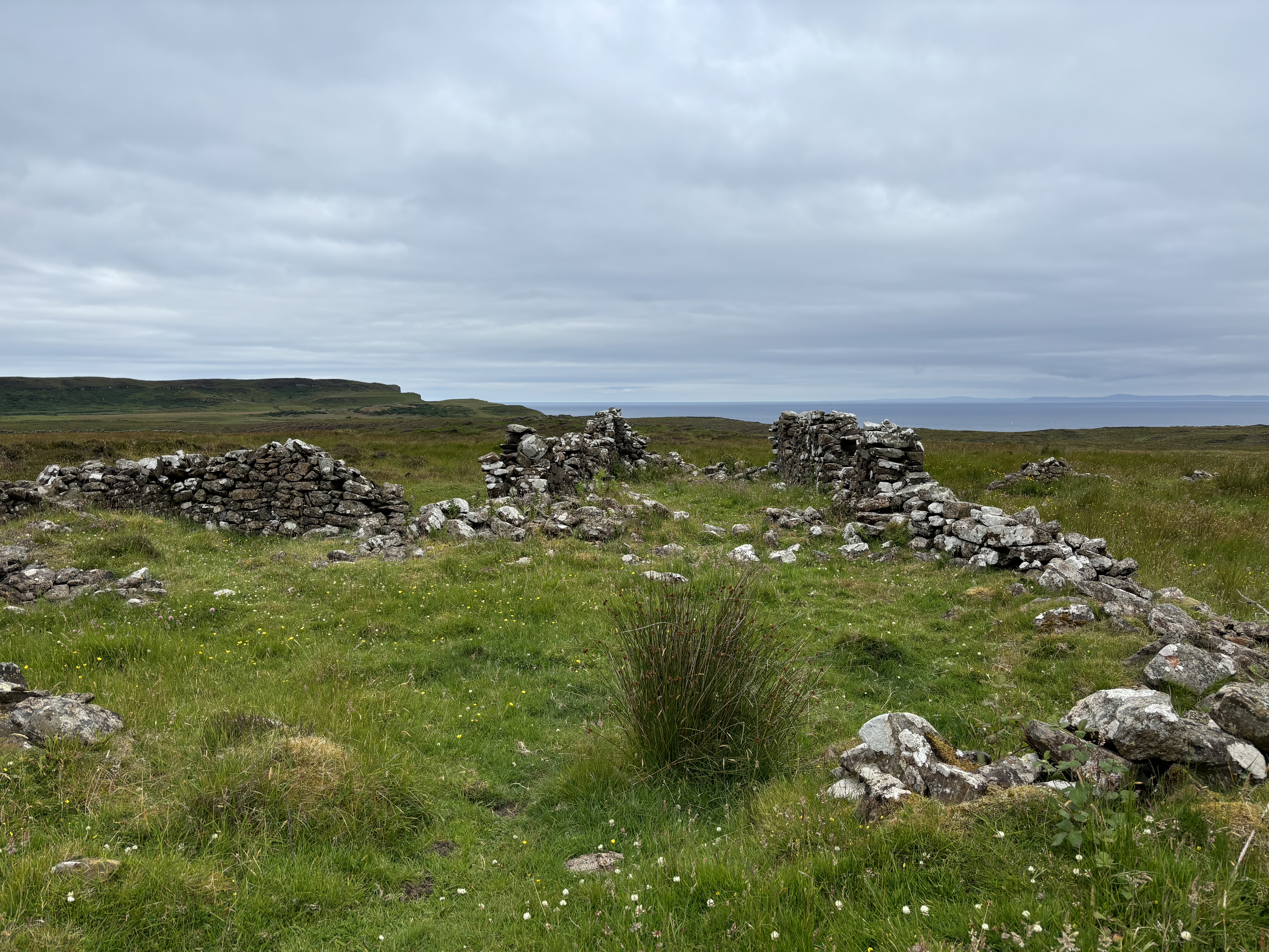
Remains of farm dwelling at Knockans (Timothy Ferres, 2024)

I saw a number of ruinous and dilapidated cottages, even clachans.

Retracing my way back to the main road, I went westwards and almost immediately saw another ruinous house which was, according to Nick Sebastian, a shop belonging to Hugh and Jessie Spears.

Remains of Spears' house from the main road (Timothy Ferres, 2024)

This shop must have been popular with the islanders up the hill.

Closer to the West Lighthouse, Kebble House - really a cottage - appears to be the most westerly dwelling on Rathlin today.

It has no permanent residents and seems to be owned by a government department today.

Keeper's room in lighthouse (Timothy Ferres, 2024)

The West Lighthouse, including the RSPB bird centre and a little museum, is a highlight of any trip to Rathlin.

It cost no less than £400,000 to construct in 1912 (about £38.4 million in 2024). 


Timothy Ferres, 2024

ON my second day I walked closer to the manor house; to Craigmacagan, now an RSPB walking trail.

It begins on the main road, inland a bit and not far from Mill Bay.

This is probably my favourite walk on the island: over beautiful wild grassy tracks, gently undulating and abounding with wild flora and fauna.


I took a little video clip of Craigmacagan above.

I went for a very brief dip in the sea, despite not having the bulky wetsuit with me.

I'm not - yet - a committed open water swimmer; though who knows? The water was not too cold and the old gnashers were not chattering anyway!

Three dinners and three breakfasts in the manor house; a visit to the celebrated McCuaig's bar at Church Bay (a mere hop, skip, and jump from the manor house; a few hours seated on a side bench with others who were watching England play Spain at football.

I am quite indifferent to team sports, so when I was asked about my choice of team, I pleaded neutrality.

I had reserved a sailing on the larger vehicle ferry at noon, though decided to take the 10am fast ferry back to Ballycastle, County Antrim; merely twenty minutes away.

Friday, 5 August 2022

Rathlin Journey

Flora at Craigmacagan (Timothy Ferres, 2022)

Something keeps drawing me back to Rathlin, Northern Ireland's only inhabited off-shore island.

The slow ferry - the larger one which can take vehicles and passengers - left at 10am on Monday morning, so I parked my car at the ferry terminus in Ballycastle, County Antrim, and made my way the hundred yards or so down to the pier.

The trip to the island takes about 45 minutes, twice as long as the fast, non-vehicle ferry.

I stayed at the Manor House for the duration of my three days on the island.

The manor house hotel is a mere hop, skip, and jump from the harbour, which is literally opposite it.

Having checked in, I immediately had a stroll around Church Bay, from St Thomas's parish church to the old Kelp Store.

I had a drink in the legendary McCuaig's Bar, where a lady from Scotland with her two little terriers was staying at the nearby glamping pods; and one of the staff, Rauri Morgan, recounted the time at his cottage where he encountered a film crew with none other than Ben Fogle for New Lives in the Wild.

Kelp Store (Timothy Ferres, 2022)

There used to be resident parish priests and rectors on the island, though this has not been the case for many years.

Kelp Store ca 1890 (Image: Rathlin Community)

The Gages, former landlords, now live at the Glebe House (former rectory) when they are on Rathlin.

Having enjoyed a good cooked breakfast at the Manor House on Tuesday morning, I donned the hiking gear and made my way to Rue Lighthouse, which is located at the southernmost point on the island.

En route there are several points of interest, including one ruinous cottage in a field near Ushet Lough, reputedly the home of William McKinley's ancestors.

Ruinous Cottage near Ushet Lough (Timothy Ferres, 2022)


McKinley, of Ulster-Scots heritage, was the 25th President of the United States.

Moving on, passing Ushet Lough, up and over undulating hilly countryside, I arrived at Ushet Port, which today comprises two derelict, roofless buildings adjacent to a small natural harbour.

Seals at Ushet Port (Timothy Ferres, 2022)

These buildings were once used as stores for imports and exports of grain, spirits, rope; and most certainly contraband!

Old steel tying post at Ushet Port)

I've read that the coastguards on the island at that time were more concerned about smuggling than saving lives.

The Rue Lighthouse is the most recent of the three lighthouses on Rathlin, having been completed about 1920.

ON Tuesday afternoon I ambled the short distance from the manor house to Craigmacagan Walking Trail, a brand new track created by the RSPB in 2022.

Undeterred by a dog warning notice and small herd of young, docile cattle, I trekked over gentle slopes, along a narrow path surrounded by heather, and was rewarded by a splendid view of the Mull of Kintyre and Scottish mainland. 

I'm glad I found this really beautiful trail.

HAVING donned the old nose-bag at eight-thirty on Wednesday morning for another big breakfast, it was time to travel westwards.

Bert's Puffin Bus was waiting at the harbour, so I paid the fare and jumped aboard for the four-mile journey to West Lighthouse and RSPB's bird centre.

Inside the centre I chatted to the wardens and enjoyed a cup of hot chocolate.

Having already been to the West Lighthouse a few years ago, on this occasion I decided to start walking towards the Kinramer Permissive Path, a short trek of about one and a half miles.

Despite abiding by the directions, unfortunately I couldn't find the signposts!

Seemingly wooden signposts can be vulnerable to passing cattle.

Still, I traversed the route which I judged it to be, towards the cliff, though ended up somewhere in the middle of rough terrain, beside a gully of some sort.

Peacock Butterfly at Kinramer (Timothy Ferres, 2022)

Whilst making my way through long, thick, and very wet vegetation I was looking down at the ground and something strikingly colourful caught my eye: a Peacock Butterfly.

I'd never seen one of these before, so it was quite a surprise for me.

It had started to rain quite steadily since my walk back to Church Bay, so I was glad that I had the hiking gear, fairly new Goretex hiking boots, and so on.

Back at the manor house I peeled off the gear to let it all dry off, and had a good old beaker of "Rosie Lea."

That afternoon, suitably replenished and refreshed, it was time to revisit the East Lighthouse, the oldest of the lighthouse trio.

This building dates from about 1850; and, as I was standing outside the lengthy wall surrounding it I watched two men on one of those suspended electric platforms painting a section of the lighthouse matt black with rollers.

I gather the Rathlin's community has ambitious plans for the keepers' accommodation beside the lighthouse, which includes at least two quite substantial residences.

There were once six keepers living here with their families (and if they had large families there could easily have been fifty or sixty souls).

My stay on glorious Rathlin ended on Thursday morning, embarking upon the ten o'clock fast ferry back to Ballycastle.

Monday, 23 August 2021

Rathlin Island Walks

Prospect of Rathlin's Harbour from the Manor House (Image: Timothy Ferres, 2021)

I last stayed on Rathlin Island four years ago, in August, 2017; its allure is quite irresistible to me.

The island's population has doubled in my lifetime, and now totals about 170.

Not so long ago the little primary school had eight pupils; whereas today that figure has increased to almost twenty.

My journey began at Ballycastle, County Antrim, where I embarked upon the ten o'clock vehicle ferry for the 45-minute sailing to Church Bay, Rathlin's nucleus.

I should explain that there are two ferries: a fast one, which takes merely 15 or 20 minutes; and a slower one, which can take vehicles.

I stayed at the manor house guest-house, ancestral home of the GAGES, landlords and proprietors of Rathlin Island since the mid-18th century.

I think they purchased the island from the Earl of Antrim for the princely sum of £1,750, the equivalent of about £400,000 today. Quite a bargain!

During my stay on the island I encountered quite a few interesting people.

Since I've already wrote a bit about the MANOR HOUSE GUEST-HOUSE in 2017, I propose to recount one or two of my walks.

On Tuesday, August 17th, I walked eleven and a half miles, from the manor house in a westerly direction to the Kinramer North and Kebble South trails.

I began my walks from the manor house, which is directly opposite the main harbour.

The weather was inclement during most of my stay, so I wore my 1990s pair of Raichle hiking boots, with waterproof over-trousers and anorak; and a little backpack with binoculars, something to drink, directions, etc.

By the way, the old hiking boots gave me trouble: one of my ankles was sore, and the boots were leaking (subsequently I purchased a new pair of Salomon Quest Four hiking-boots). 

On Wednesday, August 18th, I decided to ramble from my accommodation at the manor house towards the East Lighthouse and Ballyconaghan.

Former Pigeon-House beside the Manor House
(Image: Timothy Ferres, 2021)

As I passed the former coach-yard, attached to the manor house, I peered in and under the arch, to the left, the former pigeon-house could be seen.

What is now the island's health centre, at the other side of the arch, was once a livestock barn.

Just past the health centre there's a former coal-yard, which also has an arch and matching doors; and a distinctive carved stone erected by the Rev Robert Gage in 1816.

I walked further along Church Bay and turned left at McCuaig's Bar, up a short, steep road to a junction, where I turned right.

This used to be a busy thoroughfare on the island, with a grocer's shop, the rectory, the police station, a public house, and the smithy.

The former police station, I suspect, is on private land, so I didn't venture towards it; though I believe that it was originally called Ballynoe House, and was the residence of the MacDonnells, Earls of Antrim, who sold Rathlin to the Gages.

The Glebe House, Rathlin Island (Image: Timothy Ferres, 2021)

The Glebe House, as it's now known, was once the rectory.

The last rector to reside there, I think, was the Rev George James Boucher, Rector of St Thomas's from 1950-56.

The Gages have been using it as their island residence since about 1975.

The former Smithy, Rathlin Island (Image: Timothy Ferres, 2021)

A bit further along the road I passed the smithy or forge, where the resident blacksmith made and repaired cartwheels, nails, and shod horses.

After ten or fifteen minutes I came to a clachan or cluster of three houses up a short lane.

These dwellings belonged to the McQuilkins and the Cecils. 

The McQuilkin and Cecil Clachan (Image: Timothy Ferres, 2021)

They're all derelict and quite dilapidated, though not beyond restoration; the first house on the left probably being the most recent building. 

HAVING had a brief look through the closed gates of the East Lighthouse, I turned back along the track, and made my way to the National Trust trail.

Eventually I reached another clachan of four cottages at Crocknanagh, where more McQuilkins and Currys lived.

The Crocknanagh Clachan (Image: Timothy Ferres, 2021)

I'm told that the McQuilkins had a pretty little walled garden under the tree, where colourful shrubs thrived.

I've already written about the coastguard hut at the top of Cantruan hill and, on this occasion, I decided to omit it from my walk; so I walked back to the tarmac road, down a gently sloping incline, and walked past the Catholic church of the Immaculate Conception, built in 1864 to replace an older church.

Part of the interior wall of the previous church remains behind the present one; and a series of steps lead up to the relatively modern 1980s parochial house.

No parish priests have lived here permanently since 1999.

The former Pound, Rathlin Island (Image: Timothy Ferres, 2021)

Directly opposite the church is the children's playground, originally a small field where stray animals were impounded by the landlords, the Gages.

Anybody who owned one of these stray animals was compelled to pay a fee for its release; a considerable deterrent I imagine!

The Parochial Hall, Rathlin Island (Image: Timothy Ferres, 2021)

Beside the playground is the parochial hall, built about a century ago; and further along is the primary school, which had a mere eight pupils five or six years ago.

Today numbers are increasing, and I'm told that there are up to twenty children.

When they reach the age of eleven, they need to attend classes on the mainland. 

Former Shop opposite the School (Image: Timothy Ferres, 2021)

On the other side of the road is a tiny one-storey building with two large windows and a door.

It was closed when I saw it, though I peered inside and it seems to be an artist's studio of some sort.

It was originally a little general merchant's shop.

Islanders were generally self-sufficient in fruit and vegetables, eggs, and dairy produce.

Certainly there's a lot to explore on Rathlin.

The Cooraghy Bay pier could be developed as an industrial tourist attraction, for instance.

This pier was constructed in order to convey building materials for the new West Lighthouse about 1910.

Abandoned Pier at Cooraghy Bay (Image: Timothy Ferres, 2021)

From the top of the cliff, a series of steep concrete steps, with a single hand-rail, lead down towards the pier, though they terminate suddenly not far down the cliff, making it hazardous to attempt the descent today.

An ingenious method of hauling the building materials up was conceived with, quite literally, horse-power, winches, a derrick, and rail lines.

I purchased a very good guide called Eight Walks On Rathlin Island, written by Nicky Sebastian in 2018.

I bought it in the manor house, and heartily recommend it.