Showing posts with label Walks. Show all posts

Saturday, 3 January 2026

Mountcollyer Street, Belfast

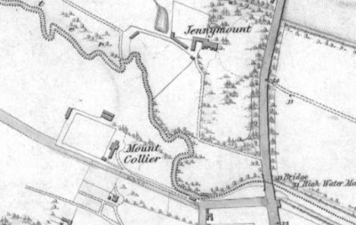
Historic Map of Mount Collyer ca 1830

Having been to see the Belfast film at Cineworld, my curiosity was aroused about that well-known actor, Sir Kenneth Branagh.

I've known about him since his acting role in the "Billy Plays" produced by BBC Northern Ireland and set in the late 1970s.

Certainly he had a convincing Belfast accent in those dramas, though Sir Kenneth actually lost his local accent within a few years of moving to Reading, Berkshire, from his home town of Belfast about 1970.

Kenneth Branagh sounds, to all intents and purposes, English. I wonder how easily he can revert to a Belfast accent?

At any rate, I was curious to find his roots in Belfast; so, with the assistance of Google maps and "sat-nav," I found the location of the Branagh home fairly easily.

They lived at 96 Mountcollyer Street until young Kenneth was about nine, when, because of civil unrest and a degree of intimidation, I think, his father decided to begin a new life away from Northern Ireland.

Mountcollyer Street runs from 32 Crosscollyer Street to Parkside Gardens; and, in 1974, there were 170 houses; John Brannagh [sic] lived in number 49; Henry Brannagh in 83.
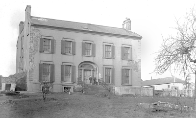
Mount Collyer House ca 1889 (NMNI/WA Green)

MOUNT COLLYER HOUSE appears to have been a Georgian dwelling of two storeys over a high basement, double-gabled.

Following several prominent clergymen including Dr William Hamilton Drummond, the textile manufacturer ANDREW MULHOLLAND, father of the first Baron Dunleath, resided at Mount Collyer till about 1846, when they moved to Springvale (Ballywalter Park) on the Ards Peninsula.

The Rev Dr James Saurin, Vicar of Belfast, died at Mount Collyer in 1772.

The Rowans seem to have been the last family to live there before the old house was demolished, and the grounds were developed for the Mountcollyer and Crosscollyer housing about 1882.

Mount Collyer features in DAB Dean's Plight of the Big House in Northern Ireland, as does Jennymount Castleton, the larger house to the north of Mount Collyer in the old map.
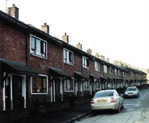
Mountcollyer Street, 2006, prior to Demolition (Chris Paton, Scotland)

Was Mountcollyer Street hit by a bomb during the Blitz? I believe so, in 1941.

The only photograph I've seen appears to be of a post-second world war terrace.

Mountcollyer Street faces Alexandra Park, so the terrace seemed only to have been built on one side.

The northern park side has always had railings as far as I know.

Young Kenneth Branagh walked through the park to Grove primary school in the 1960s (the school closed in 2010).

It's on a gentle slope, and was probably a pleasant part of town to live in, being so close to the park and playgrounds.

Local residents insisted that it's not in "Tiger's Bay" area.

Approximate Location of 96 Mountcollyer Street (Timothy Ferres, 2022)

I encountered three local residents, two of whom remembered the street before it was demolished.

They pointed out the approximate location of Number 96.

I imagine that new houses will eventually be built on the present wasteland.

First published in 2021.

Saturday, 16 August 2025

6 College Gardens

College Gardens, Belfast (Timothy Ferres, 2021)

I motored over to Belfast's University Quarter in a sunny February day in 2017.

There were spaces on Elmwood Avenue, so I parked, ambled towards Lisburn Road and turned in to College Gardens, a street which runs from 95 University Road to Lisburn Road.

One entire side of College Gardens comprises Methodist College or "Methody"; the opposite side, terraced town-houses and flats.

I was curious to see number six, because it used to be the home of Field Marshal Sir John Dill's father.

John Dill was a branch manager in the Ulster Bank. (The bank, today, still has a branch on the University Road side of the 1970s block).

It transpires that the said house is long gone and numbers 1 to 6 are now a two-storey block, viz. Queen's University's old Common Room.

The College Gardens side of this block - the ground floor - is now the premises of Deane's at Queen's restaurant.

4-7, College Gardens, Belfast, 1896 (Image: Northern Ireland Historical Photographical Society)

I suppose the original terrace was demolished in the early seventies to make way for the more prosaic block we have today.

Thence I strolled over to the Ulster Museum, where there was an informal talk taking place about the museum's two paintings of "Spring" and "Winter" by Pieter Brueghel the Younger.

Thereafter I continued my amble, along University Road and past Camden Street, where a friendly cat basked in the sunshine.

Anybody who knows me will know that I never pass a cat without greeting it, and this large ginger number was no exception.

Two young women accosted me and inquired if I knew the owner of Ginger (no).

They were concerned that Ginger was alone, taking the benefit of the sun.

One of them spotted that Ginger had a collar with name-tag and phoned the number.

False Alarm!

Ginger was, it would seem, accustomed to spending some time on Camden Street.

First published in February, 2017.

Saturday, 28 June 2025

Mount Charles Walk

On Sunday, April 23rd, 2023, I parked the car at Upper Crescent and walked a short distance to the adjacent Mount Charles.

Mount Charles, Belfast, runs from 36 University Road to 57 Botanic Avenue.

This street has a distinct air of privacy and seclusion about it: Victorian gate piers adorn each end.

The Belfast street directory of 1974 tells us that Number Four, the second villa to be built, was occupied by the Queen's University and Miss D D Rankin MBE; and Henry W Donaghy resided at Number Six.

Numbers 2-6, Mount Charles, ca 1860 (historic OS map)

These little villas, built about 1842 in the Greek-Revival (or Regency style, according to others) are the finest buildings in Mount Charles, and greatly enhance its undoubted charm.

Mount Charles itself was built or developed by Bernard "Barney" Hughes (1808-78).

Gate pier beside 2, Mount Charles, Belfast (Timothy Ferres, 2023)

The first person to reside at Number Six was, it is believed, James Bruce (1808-61), editor of the Northern Whig newspaper in Belfast.

2-4 Mount Charles in the 1920s (Hogg Collection/Ulster Museum)

William J Shaw resided here briefly, followed by William Grey (1830-1917), district surveyor for the Board of Works in Belfast.

2-4 Mount Charles (Timothy Ferres, 2024)

At the beginning of the 20th century Mount Charles was acquired by Sir John Fagan JP DLson-in-law of none other than Barney Hughes.

6, Mount Charles (Timothy Ferres, 2023)

Number Six continued to have a number of tenants until at least 1974; since 1990, however, the house has not been, to my knowledge, residential.

The three villas were devastated by terrorist bombing in 1973 and 1974 (Robert McKinstry and Melvyn Brown restored the first two in 1982).

The Queen's University of Belfast appears to own Mount Charles today.

Upper Crescent, Belfast (Timothy Ferres, 2023)

On my way back to Upper Crescent I passed the Crescent Church, which stands on University Road, sandwiched between Upper and Lower Crescent.

Greek inscription at Crescent Church (Timothy Ferres, 2023)

The Greek inscription above the church's porch is doubtless intended to allure Classical students of the Queen's University to its fold on the sabbath.

Saturday, 5 August 2023

Belfast Castle Walk


The prospect from Belfast Castle was splendid on New Year's Day, 2017.

I donned the sturdy walking shoes, stuffed a few items in the little haversack, and drove across Belfast to Cave Hill in the north of the city.

As I drove along the Antrim Road, I passed the Castle's only gate lodge, an elaborate structure built in a similar style to the mansion itself, replete with monograms, coronets and armorial bearings of the Chichester family, Marquesses of Donegall.

I motored up the winding drive and managed to find a parking-space close to Belfast Castle.

The Estate Trail walk takes about forty minutes.

Some of the signage along this route was slightly worn and in need of bolder paint.

Steam lift in the basement
The 3rd Marquess of Donegall was quoted as saying that his Ormeau estate was "under a disadvantage for want of a more suitable family residence."

Despite being in constant debt, he decided to construct a new mansion house at lands he still owned in the deer park to the north of Belfast.


W H Lynn, the architect responsible for the design of Belfast Central Library and the Bank Buildings, had designed a mansion for Lord Donegall's sister-in-law in County Tipperary, and was approached to design his lordship's new mansion at Deerpark.

The proposal to build was announced in 1865, though construction was delayed due to a legal dispute between Lord Donegall and his neighbour (he originally intended to build his new house too close to his neighbour’s property).


Lord Donegall's father, the 2nd Marquess, had squandered the family fortune to such an extent that his son was left with a very considerable burden.

The Donegall wealth had dwindled so drastically that the project was almost left unfinished.

However, the 3rd Marquess's son-in-law, Lord Ashley (afterwards 8th Earl of Shaftesbury), who had married Lord Donegall's only daughter, the Lady Harriet Chichester, effectively bailed his father-in-law out.

The cost of constructing the Scots-Baronial mansion was originally estimated to have been £11,000 (£1.2 million today).

However, the expense was considerably underestimated, resulting in the 3rd Marquess becoming embroiled in yet more debt.

The very construction of Belfast Castle was threatened.

The project was saved by Lord Ashley, who acted as guarantor and paid the outstanding sums.


Belfast Castle remained the residence of Lord Donegall for a mere 14 years (1870-84).

Tragically his only surviving son and heir, Frederick Richard, Earl of Belfast, had died in 1853.

The Castle was the Ulster residence of the 9th Earl and Countess of Shaftesbury until 1934, when Lord Shaftesbury presented the house and grounds to the City of Belfast.

Lord Shaftesbury served the office of Lord Mayor of Belfast in 1907 and was appointed Chancellor of the Queen's University of Belfast the following year.

First published in January, 2017.

Tuesday, 13 April 2021

The Stupendous Trip

Have you ever tripped, or been tripped up, in a field or footpath? I'm quite sure it has happened to most of us.

Yesterday I was on my way home from a four or five mile walk, striding briskly along the footpath near St Mark's parish church.

The footpath wasn't particularly wide, and another pedestrian approached me from the opposite direction.

I naturally veered to the side of the footpath, and we smiled and nodded at each other as I passed.

Thereafter events moved at the blink of an eye.

I tripped and fell instantaneously to the ground.

I immediately looked back while I lay on the pavement, though by this stage the other walker had passed me, unaware of what had happened, and wearing headphones.

All was quiet at any rate, because there were no other pedestrians or traffic.

I had a look on the ground to see what had happened, and there was a large metal hoop of some sort which, obviously, had been the cause of my fall.

I had been acknowledging the passer-by without observing or seeing this cause of my ignoble fall from grace.

Fortunately I was completely unhurt, being nimble, fit, and healthy.

I escaped unscathed, apart from my pride - quite bemused, actually -  without even a bruise, ache, or scratch.

I lifted the offending object to examine the cause of my fall, and was tempted to throw it away as forcefully as feasible; though instead decided merely to place it on top of a hedge.

"Mind how you go", as Detective Inspector Fred Thursday might have said.

Sunday, 5 July 2020

Hillsborough Forest

Hillsborough Fort. Image: Timothy Ferres, 2020

Hillsborough, County Down, is undoubtedly one of the pleasantest and most interesting villages in Northern Ireland.

It has been ages since I last paid Hillsborough Forest a visit, so I wasn't disappointed today.

Hillsborough Forest Lake. Image: Timothy Ferres, 2020

The Fort, former home of the Hills, Earls of Hillsborough and Marquesses of Downshire, stands overlooking the lake in the forest.

It seems to be in good order, and the old stone steps leading down through the undergrowth towards the parish church can still be seen.

The church and fort are adjacent to each other.

It was a joy to see so many young families with their toddlers and children enjoying the forest walks and the swans, geese, and ducks feeding at the edge of the lake.

Today I walked around its circumference, then out through the gates, via Park Lane, to the Square; and down the main street to the junction where the parish church can be seen from its long avenue.

Image: Timothy Ferres, 2020

The statue of Arthur, 4th Marquess of Downshire, KP, faces the church directly from across the road.

The town-houses on the hilly main street, with their courtyards and mews, are simply charming; as are the little artisan shops and gastro-bars.

Image: Timothy Ferres, 2020

At the top of the main street, on the Square, stands the old court-house, which itself stands opposite the main entrance to Hillsborough Castle, former home of the Downshires, then the Governors of Northern Ireland, Royalty, and Secretaries of State.

Saturday, 20 June 2020

The Red Trail

The Original Hut in 2016

Mount Stewart's Red Trail opened four years ago.

I first explored the trail on a glorious Sunday in May, 2016.

It was sunny and pleasantly warm.

After lunch at home I got a few things together and motored down the Ards Peninsula to Mount Stewart estate, a property of the National Trust, though formerly the ancestral seat of the Stewarts, Marquesses of Londonderry.

The Red Trail runs on land to the south-east of the demesne.

Having ambled past the Lookout and had a look in the shop inside the mansion house, I donned the wellington boots, ensured that my camera was in the pocket, and began the walk.

The Red Trail starts at a quaint little shepherd's hut, a sort of information centre for greeting visitors.

I walked in and chatted for several minutes to the person on duty.


The trail cuts through woodland and then there was a gradual ascent to Temple Hill and the Temple of the Winds, an octagonal building perched at the top of the hill, with a spectacular prospect of Strangford Lough.

The Temple was inspired by the Grand Tour the 1st Marquess took in his youth.


From here we begin a descent, walking on fairly level ground through enchanting woodland to the north-west of Patterson's Hill.

Eventually I emerged at a clearing, where there is a very large field at Cumming's Hill.

To my right, isolated and overgrown in semi-woodland, there's an old, derelict stone lodge or cottage.

It was doubtless inhabited by an estate worker and his family, perhaps a woodsman or gardener.


It appears rather romantic now, with the creeping ivy and resident crows, a pair of which I disturbed.

The windows are open to the elements.

Hopefully, in time, this will be restored as a holiday cottage.

Downpatrick Lodge and North Lodge at Castle Ward were both once derelict for many years until they were restored; and now they have tenants.

I continue my walk, northwards towards Bell's Hill.

The Glen Burn, a small river, runs alongside the Red Trail for part of the way.

Between Cumming's Hill and Bell's Hill there is a glen, where I made a short detour past picturesque little hump-back bridges to The Folly, at ruinous cottage ornée at the top of a hillock.

The Folly

It has the familiar Gothic window apertures seen, too, at the old schoolhouse; only the bare walls remain, though, and there is evidence of plasterwork on some of them.

This ruinous building aroused my curiosity.

There's something particularly special about walking new trails and discovering unknown features for the very first time.

According to my old chart there are the ruins of an old chapel or church at the extreme north of the Glen; at the edge of the estate, in fact.

Continuing my walk I begin a slight climb, past Bell's Hill, to the old piggery; then through a handsome, new, wooden gate which leads to a small track.

This track winds its way up New Hill, though a carpet of bluebells and woodland. It is relatively steep.

New Hill descends towards sea-level and brings one back to the start of the trail again.

First published in May, 2016.

Sunday, 14 June 2020

Hare's Gap Trek

The Hare's Gap in the distance
Why do some people dump litter? I'm a great believer in the Leave No Trace principle. You'd hardly know I'd been.

I even get irritated if, in a gale or gust, a tissue or plastic wrapper inadvertently blows away from me.

Plastic bottles seem to be among the worst offenders. They weigh so little when they're empty. Their owners might as well carry them home.

On Sunday, the 13th June, 2020, I went on another mini-hike, this time to the Hare's Gap in the Mourne Mountains, County Down.


I suppose Bryansford is the nearest village. Trassey Road leads you to a small car-park, though it was completely full at 10am, and lots of cars were parked along the narrow verge.

Trassey Track, as it's known, leads directly to the famous Hare's Gap, a kind of col nestled between Slieve Bearnagh and Slievenaglogh.


At this time of year Foxgloves proliferate the Mournes; such beautiful wild flowers they are.

The track follows the Trassey River for part of the way.


It's a fairly gentle ascent, by Mourne standards, and takes perhaps an hour or so.

The Mourne Wall at Hare's Gap

The scenery is magnificent on a clear day, and the col at the top is a good place to have a snack and enjoy the prospect.

The old Raichle boots have served me well during their twenty-five or more years.


I descended along a path that skirts Slieve Meelmore for some distance, before joining the track itself.

Later on I drove through Bryansford and into Newcastle, where I found a parking space at the top of King Street.

King Street is an interesting road. It leads to the former gate lodge of Donard Lodge, and what appears to be a former walled garden (now developed inside).

There are some handsome and admirable villas in King Street.


Having parked I strolled in a triangular route between the old gate lodge, the harbour, and the old parish church (on the 'rock').

The church was closed, though the Annesley arms adorn its main entrance.

The former Annesley estate office and hall are here, on the promenade.

Sunday, 29 December 2019

Upper Crescent's Revival

University Square from Botanic Avenue, December, 2019

Dear readers, I have just returned from an inspiring walk at Belfast's University Quarter and, in particular, Upper Crescent, Botanic Avenue, Rugby Road, Botanic Gardens, and University Square.

I have to confess that Sir P G Wodehouse's fantastic and wonderful characters, Bertie Wooster and his valet, Jeeves, sometimes spring to mind; so be mindful of a twinkle in the eye as I tap away at the keyboard.

For those of you who have not been zealously following the Belmont narrative since its inception in 2007, I have always had a fondness, bordering on nostalgia, for the Botanic and Stranmillis areas of Belfast.

Much of it is still recognizable, though the Arts Theatre has been closed for decades.

When I was a schoolboy in short trousers we used to queue on Botanic Avenue for matinées and pantomimes there.

I invariably admire University Square, still one of Belfast's finest terraces.

Many pre-eminent physicians and surgeons had consulting-rooms here fifty years ago.

My mother took me to one of them for a sinus ailment in the 1960s.

Rugby Road is an interesting street which runs from University Avenue to Agincourt Avenue.

It comprises mainly terraced townhouses, though there are about half a dozen detached houses at one end, closely beside one another.

Interestingly I could see no basements, though they are quite lofty residences with three or four storeys.

Rugby Road terminates at Agincourt Avenue, though a small terrace known as 'Botanic Court' is tucked in at a side entrance to the park.

Botanic Primary School occupies almost an entire side of the terrace.

Map of ca 1850-60

MY fondness for Upper Crescent should not be underestimated.

I wrote a bit about it five years ago.

Numbers Eleven and Twelve are about to be restored as apartments, thank goodness.

As far as I am aware they have lain derelict and neglected for ages.

Incidentally, if you fancy a period pied-à-terre in town, look no further.

11-14 Upper Crescent, Belfast, December, 2019

Numbers Eleven and Twelve, Upper Crescent are being restored as apartments.

 87-91, Botanic Avenue, also be be restored as flats, was the Botanic Lodge guest house for many years.

87-91, Botanic Avenue, December, 2019

The handsome Victorian (Neo-Regency?) townhouses of Upper Crescent formed part of a three-storey residential terrace built in 1846 by Robert Corry.

Number Eleven was occupied by James Greene (First Clerk, Custom House), followed by Mrs Herdman; and, by 1860, William McNeill.

By the late 1870s, James Festu resided there and, in 1899, the house was home to William Yates; then, pre-1920, the Rev William Beatty; and then T Bell, who remained there from the mid 1920s to the 1960s.

By 1970 the property had been converted into office accommodation.

Number Twelve was originally occupied by Robert Boag (Mayor of Belfast, 1876-7), of Albion Clothing Company, possibly the same person, though likely a father and son.

By 1920 it had become the Crescent Private Nursing Home, though reverted to an conventional dwelling again by 1930, with Miss Mabel Simms in residence.

Miss Simms remained there until at least 1960, but by 1970 the building had been converted into office accommodation.

Numbers Fourteen to Sixteen, Upper Crescent, are also to be restored, by the way.

Monday, 8 July 2019

Donard Walk


Heaven knows how the poor dogsbody managed to retrieve provisions from Lord Annesley's ice-house.

This beehive-shaped stone structure was built in the late 1830s to serve Donard Lodge (probably by the 3rd Earl Annesley before he died in 1838).

It is built into the north side of Thomas’s Mountain, just above the tree-line, very close to the Glen River.

Click to Enlarge

The National Trust, which owns Slieve Donard, repaired it two decades ago, with a large section of the main dome rebuilt.

As I passed the ice-house on the other side of the river, I couldn't see any trace of a path leading to it.

I even checked a historic map of that era.

The weather forecast was good, and it had been many years since I last ascended Northern Ireland's highest mountain, Slieve Donard, so I packed the rucksack, found the trusty Swiss hiking boots, and motored in a southerly direction to Donard Park, Newcastle, County Down.

Slieve Donard is 2,790 feet high, incidentally.

This is the spot where the Mournes sweep down to the sea.

The Earls Annesley, of Castlewellan Castle, owned all the land from Slieve Donard to Slieve Croob, including Newcastle and Donard Park.

They had a holiday home, rather grandly known as a maritime residence, called Donard Lodge, which afforded a wonderful prospect of the whole area and the sea.

I parked carefully at the park, dressed appropriately, and began the ascent at 9.33am.

It wasn't very busy at this time of the day, so I made good progress.

I even asked another hiker to take my photograph at the spot close to where I thought the Mourne fell-walkers posed for the BBC "Oneness" theme.


En route I encountered many friendly people, including two lovely youngish ladies, one of whom admired my legs; and another my smile!

Eric Morecambe always used to tease Ernie Wise about his "short, fat, hairy legs."

I'm fairly fit for my age: I swim six miles a week, after all.


I reached the summit at about 11.20am, so it took me about one hour and forty-seven minutes.


There were about a dozen people there when I arrived, though many more arrived later.

Having eaten the banana sandwiches with a drink of water, it was time to make the descent.


Belmont the Conqueror, of Donard.

By the time I was leaving there was a constant stream of hikers, of all ages, making their way like a long queue of pilgrims.

The Mourne Mountains are the domain of the noble raven: I saw two today.


Back at Donard Park, it was heaving with cars; in fact there was a tailback into and out of Newcastle.

Despite the temptation to drive over to the Slieve Donard Hotel, I judged it best simply to motor home.

Monday, 23 May 2016

Cregagh Glen


Cregagh Glen is a spot where the city of Belfast meets the countryside.

It is a property of the National Trust.

Parking is not particularly easy from the Knockbreda end, though I managed to find a place at a road off the dual carriageway; take care, however, if you park on the other side of the ring road.

This is a linear route, which returns by way of the same path.

My walk began at the entrance on the Upper Knockbreda Road.


I followed the path uphill through beautiful Cregagh Glen.

At certain points along the glen you can choose to follow the main path or a smaller path along the river Glen itself.

The path stays close to the edges of Cregagh Glen as it ascends through pools of sunlight cast by the trees.

Eventually you encounter a waterfall, and yesterday there were carpets of bluebells and wood anemones.


A sign points towards the former American military cemetery at Lisnabreeny, which is worth a detour.


At the top of the glen I crossed the busy Manse Road via a walkway and skirted the grounds of Lisnabreeny House, now a school.


A lane passes Lisnabreeny House, once the home of the Robb family; briefly a youth hostel and army headquarters; before restoration as part of Lagan College.


The old garden is now replanted with broad-leaves and a children's den in the natural play area.

I ambled for some distance further along the country lane before turning back and retracing my footsteps.