 |
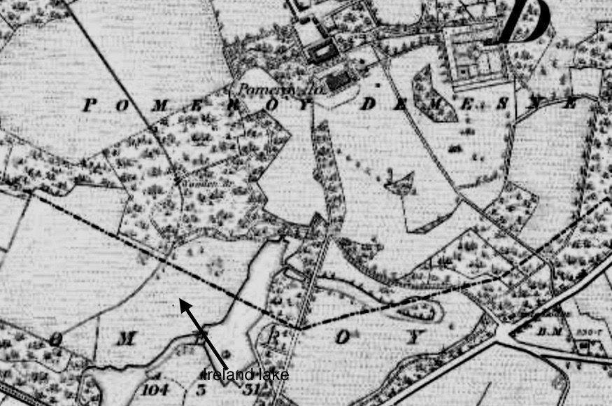
| Pomeroy Demesne: Historic OS map of 1838-62 |
I recently visited the marvellous Pomeroy forest park.
A handsome new visitor centre has been built on the site of the 1960s forestry school and, before that, Pomeroy House.

Pomeroy House, by the way, was a mere eighty feet from the extant stable-yard; very regrettably the big house was demolished about 1970, like so many others in Northern Ireland that the forestry service discarded.
I spent four hours exploring the forest park, examining various locations, including the outbuildings, former sheep-wash, kennels, farm-yard, and the Alexander Vault.
I searched in vain, however, for a lake or pond in the shape of Ireland.
The Topographical Dictionary of Ireland, dated 1837, remarks:-
Whereas the present Register of Parks, Gardens and Demesne of Special Historic Interest in Northern Ireland states:-
"In the demesne, which consists of 556 acres, is a small lake, the borders of which resemble in shape the coast of Ireland, on a scale of about one foot to a mile."
"In the south-west section of the park, flanking the west avenue, were a series of three inter-linked artificial lakes, which was fed from water from the north-east. According to Samuel Lewis in 1837 the main lake was made in the shape of Ireland at a scale of 1- inch to 1-mile and stated by him to lie adjacent to 'an abundant' spring; this lake remains as a shallow boggy area enclosed in what is now coniferous woodland."
I have studied several historic maps of Pomeroy Demesne.
I could not see any lake or pond in the map of 1829-35; in the next version, however, dated 1838-62, there are what could have been a few lakes at one time, including a larger one that vaguely resembles the coast of Ireland.
It's a boggy area, and by 1900 these ponds or lakes had vanished from the map, though the location is marked Lake Wood and Town Bog.
I am convinced that, if there was ever an Ireland-shaped lake, the boggy area to the south-west of the mansion house contained it; especially given that it is marked as Lake Wood on a map.


