 |
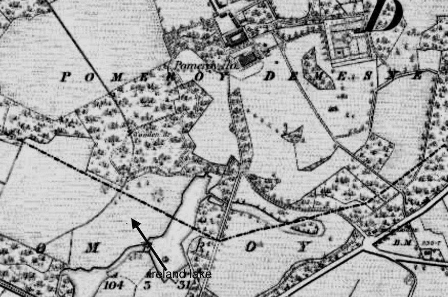
| Pomeroy Demesne: Historic OS map of 1838-62 |
I recently visited the marvellous Pomeroy forest park.
A handsome new visitor centre has been built on the site of the 1960s forestry school and, before that, Pomeroy House.

Pomeroy House, by the way, was a mere eighty feet from the extant stable-yard; very regrettably the big house was demolished about 1970, like so many others in Northern Ireland that the forestry service discarded.
I spent four hours exploring the forest park, examining various locations, including the outbuildings, former sheep-wash, kennels, farm-yard, and the Alexander Vault.
I searched in vain, however, for a lake or pond in the shape of Ireland.
The Topographical Dictionary of Ireland, dated 1837, remarks:-
Whereas the present Register of Parks, Gardens and Demesne of Special Historic Interest in Northern Ireland states:-
"In the demesne, which consists of 556 acres, is a small lake, the borders of which resemble in shape the coast of Ireland, on a scale of about one foot to a mile."
"In the south-west section of the park, flanking the west avenue, were a series of three inter-linked artificial lakes, which was fed from water from the north-east. According to Samuel Lewis in 1837 the main lake was made in the shape of Ireland at a scale of 1- inch to 1-mile and stated by him to lie adjacent to 'an abundant' spring; this lake remains as a shallow boggy area enclosed in what is now coniferous woodland."
I have studied several historic maps of Pomeroy Demesne.
I could not see any lake or pond in the map of 1829-35; in the next version, however, dated 1838-62, there are what could have been a few lakes at one time, including a larger one that vaguely resembles the coast of Ireland.
It's a boggy area, and by 1900 these ponds or lakes had vanished from the map, though the location is marked Lake Wood and Town Bog.
I am convinced that, if there was ever an Ireland-shaped lake, the boggy area to the south-west of the mansion house contained it; especially given that it is marked as Lake Wood on a map.


1 comment :
A “children’s magical storybook adventure trail with iconic sculptures, interactive fun/art pieces and natural inclusive play areas.” Oh dear. It doesn’t sound like my cup of tea at all. They’ve done something similar in Hillsborough Forest Park. Nobody ever thinks to leave a pleasant walk through a managed forest just as it is. When and why did everything have to become “child-centred”?
Post a Comment